Urban75 Home About Offline BrixtonBuzz Contact

Archaeological discoveries, breakthroughs and theories

An important stone at Stonehenge came from Scotland, apparently:


Important because it indicates a greater level of social complexity than we might otherwise have supposed.
 
An important stone at Stonehenge came from Scotland, apparently:


Important because it indicates a greater level of social complexity than we might otherwise have supposed.
The book I bought in the shop when I visited Skara Brae seem to suggest the ritual complex on the islands became a centre that linked up right across Britain, as if they were spreading their religious or whatever ideas. Only dimly recall the theory and not got book to hand, but was first thing that occurred to be when they mentioned the Orcadian geology.
 
And it's not just the Pritani who were united in a large scale network. If the research in this link is valid, then the hunter-gatherers of today's central africa were also part, long ago, of a continent-spanning set of social relations:

 
And it's not just the Pritani who were united in a large scale network. If the research in this link is valid, then the hunter-gatherers of today's central africa were also part, long ago, of a continent-spanning set of social relations:


N and S America as well.
 
This isn't a breakthrough as I understand it's been known for some time, but - during a recent visit to Ireland, my gourd was blown when I learned (in the prehistoric section of Dundalk's County Museum) that the earliest humans arrived in Ireland c.10,000 years ago. This is extraordinarily recent when compared with remains of Homo heidelbergensis found in England and dated c.500,000 years ago.

I assumed the difference was on account of Doggerland linking England, Scotland and Wales to continental Europe.

However, this National Geographic map of prehistoric Europe indicates the land beneath the Irish Sea being above sea level 18,000 years ago (i.e. 16.000BC). So why was Ireland so (comparatively) recently populated by Mesolithic humans? Did the Emerald Isle's notorious rainfall deter people from settling there? :D

Or, more seriously, is there any significance in the 16,000BC-era ice sheets (on the National Geographic map), covering much of Scotland, and another ice sheet encompassing much of Fermanagh, Tyrone, Armagh, Monaghan, Cavan and Leitrim? Do these suggest that the surrounding areas were bleedin cold and most inhospitable, only becoming liveable with rising temperatures c.8,000BC, by which time there was still a land bridge from Donegal / Derry to western Scotland, appears to be roughly Argyll & Bute?
 
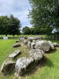
A couple of other things that twisted my melon while visiting Dundalk County Museum's prehistoric section (more than a section, in fact it's an entire floor 😍 ) was that despite Co.Louth being one of the smallest (or the smallest) of Ireland's counties in terms of its geographical surface area (square miles or rather kilometres), it's one of the richest in terms of the number and quality of its prehistoric finds, and of still-extant monoliths, dolmens, passage graves etc. We only stayed in Dundalk itself for a couple of days (the rest of our week was further south on the coast at Annagassan) but during that time I saw two or three top quality sites: this one is Proleek portal tomb (the name apparently derived from proilíg, meaning 'obscure' :D) ...
 

Attachments

  • IMG_3174.JPG
    IMG_3174.JPG
    218.5 KB · Views: 3
  • IMG_3172.JPG
    IMG_3172.JPG
    297.6 KB · Views: 3
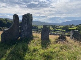
...and this is Clontygora court tomb - astonishing views from here, looking down to Carlingford Lough, and over towards the Mourne mountains... (actually I've just realised this was just over the border in the North, Co.Armagh)

It seems there was a lot of prehistoric trade and exchange between Scotland (and possibly the Isle of Man) and this part of Ireland, hence the richness and variety of finds turned up in farmers' fields.
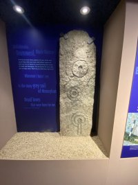
I was familiar with the idea of a Neolithic culture that began in Iberia and which had gradually moved along the coast up to France, Ireland, and the northwest of England - the distinctive spiral markings (third pic) and other decorative marks often found on their stones are (as I understand it) distinct to these areas and less likely be found on SE England's Neolithic stones.
e.g. the Calderstones in Liverpool feature these markings (and also a more recent engraving of 'J.L.', allegedly carved by a young Lennon who'd lived in the area :D) are similar to those of Spain, Portugal, France, Ireland.
BUT... a brief caption in the Dundalk museum suggested that this decorative style may have originated in Ireland and worked its way down to Iberia?! Surely carbon dating of organic material found at these sites would be able to prove / disprove this? I love the idea though - 'how the Irish saved civilisation' not once but twice 😍
 

Attachments

  • IMG_3136.JPG
    IMG_3136.JPG
    324.7 KB · Views: 3
  • IMG_3137.JPG
    IMG_3137.JPG
    472.1 KB · Views: 3
  • IMG_3186.JPG
    IMG_3186.JPG
    111.7 KB · Views: 3
Analysis of arrowheads at the Bronze Age battle site in Tollense suggest it may have been the earliest known European inter-regional conflict: Warriors from the south? Arrowheads from the Tollense Valley and Central Europe | Antiquity | Cambridge Core
The arrowhead data hint at the presence of foreign fighters in the Tollense Valley, probably deriving from southern Central Europe. This leads to questions about governance, warfare and mobility at the dawn of the Urnfield period in the thirteenth century BC; for the first time not only trade and cultural exchange, but also warfare on a supra-regional scale, can be documented in Central Europe.
 

“Scientists have traced the genetic underpinnings of our ability to digest carbs to more than 800,000 years ago, long before the advent of agriculture— and much earlier than previously thought.


This finding raises new questions around our hunter-gatherer ancestors' diet and lifestyle. It also challenges the long-held belief that a protein-rich diet was responsible for the increase in human brain size, scientists suggest.


Perhaps carbs, not meat, gave humans the energy needed for developing bigger brains.“
 
Sites of two massive cities at altitude in Uzbekistan rediscovered, seem to have thrived due to Silk Road trade: Archaeologists Map Two Forgotten Medieval Cities That Flourished Along the Silk Road in the Mountains of Central Asia
Mapped using lidar-equipped drones:
The drone-lidar scans provided remarkably detailed views of the plazas, fortifications, roads, and habitations that shaped the lives and economies of highland communities, traders, and travelers from the sixth through 11th centuries in Central Asia. The two cities are located in rugged terrain 2,000 to 2,200 meters above sea level (roughly comparable to Machu Picchu in Peru), making them unusual examples of thriving mountain urbanism.

The smaller city, today called Tashbulak, covered about 12 hectares, while the larger city of Tugunbulak reached 120 hectares, “making it one of the largest regional cities of its time,” Frachetti said.
 
Really nice story of one man's commitment to finding neolithic monuments on Dartmoor:


Somewhat typically the Guardian Graphic map seems to contain no key or legend, so I'm assuming the blue dots represent the neolithic monuments:

1731679561371.png
 
Meet Flaccus

“It is a unique find because it is not only the oldest Roman grave in Heerlen, but also because no name was known there before,” the statement reads.

The find was dated to the year 0 and is the “most unique evidence of Roman habitation at this location.” Researchers had not previously found a Roman grave for this period accompanied by a name in the region.


I wonder if distant relative of this guy

1734096811254.png
 
Meet Flaccus

“It is a unique find because it is not only the oldest Roman grave in Heerlen, but also because no name was known there before,” the statement reads.

The find was dated to the year 0 and is the “most unique evidence of Roman habitation at this location.” Researchers had not previously found a Roman grave for this period accompanied by a name in the region.


I wonder if distant relative of this guy

View attachment 454738
Who's that? American footie player?
 
This is totally cool


Few examples of this type of shield have survived over the millennia, even though it is well known from depictions in art. The Dura-Europos shield gives archaeologists a huge amount of information about how this piece of armor was made. Several layers of wood strips were laminated together to make a surface that was 41.5 inches (105.5 centimeters) tall, 16 inches (41 cm) wide, and about 0.2 inches (6 millimeters) thick. It had been shattered into 13 pieces and was missing its "umbo" or boss — a cup-shaped piece of material that would have protected the central hole where the soldier held onto the shield.

The front of the shield was covered with kidskin, then painted. According to the Yale University Art Gallery, "the painted decoration reflects Roman iconography of victory, including an eagle with a laurel wreath, winged Victories and a lion."
 
Back
Top Bottom