Urban75 Home About Offline BrixtonBuzz Contact

Brixton Liveable Neighbourhood and LTN schemes - improvements for pedestrians and cyclists

the idea of a low traffic neighbourhood is to keep traffic on the main roads where it belongs and stop satnavs filling every minor road to capacity as well.

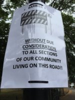
So thats ok then . People who live on these roads will just have to put up with it.
 
Unfortunately chl is the A2217 so is classed as a main road

That does not mean that all traffic has to be funneled into it. That is a political decision.

Its not a main road so that cars due to LTN have to use it to get from one point to another in roundabout route.
 
the idea of a low traffic neighbourhood is to keep traffic on the main roads where it belongs and stop satnavs filling every minor road to capacity as well.
If that's the problem I wonder how difficult it would be to work with the sat nav manufacturers to create a solution. E.g. classify roads down which vehicles are not to be directed unless the journey ends there or there is no other route.
 
If that's the problem I wonder how difficult it would be to work with the sat nav manufacturers to create a solution. E.g. classify roads down which vehicles are not to be directed unless the journey ends there or there is no other route.
It's just lag, isn't it? I've no idea how statutory road entry changes are propogated and synchronised for satnav/map updates, but I thought Google Maps was pretty quick to show the SMR & Railton restrictions. They've apparently been a bit tardy about Ferndale, but that might be how it fits with their update cycle or something.. The other players are much smaller.

Or maybe they're swamped with brochure reading planners all over the country taking the Covid opportunity to buy lots of road signs and add to their CV. :hmm:
I was meaning ongoing. If satnavs are keeping the side roads congested as thebackrow suggested. Then there might be less need for gates.
 
Once the software knows where restrictions are it'll stop routing that way.
And I'm saying that the same could be achieved, without putting any gate in. By roads being designated in a new way which has to be recognised in routing software.
 
From yesterday. The street by the Herne Hill end was painted with the same dots as Shakespeare Road at some time in the early morning.

From watching it for an hour today - <30 cars drove through, including an ambulance and a police car and 4 buses. 10 cars u-turned.

Milk wood and Dulwich Road are quiet.
 

Attachments

  • DFA9566A-052E-4632-9557-B8652D9A7A2E.jpeg
    DFA9566A-052E-4632-9557-B8652D9A7A2E.jpeg
    692.6 KB · Views: 9
  • E25128A8-2A59-4CFA-A27E-F63374F4B30B.jpeg
    E25128A8-2A59-4CFA-A27E-F63374F4B30B.jpeg
    355.1 KB · Views: 9
And I'm saying that the same could be achieved, without putting any gate in. By roads being designated in a new way which has to be recognised in routing software.
The whole point of satnavs (and especially Waze) is to identify ratruns. Waze even highlight police mobile speed traps do that drivers can break the law without getting caught. If one company agreed to “avoid” certain roads another would doing up with a product that didn’t
 
The whole point of satnavs (and especially Waze) is to identify ratruns. Waze even highlight police mobile speed traps do that drivers can break the law without getting caught. If one company agreed to “avoid” certain roads another would doing up with a product that didn’t
Yes - I understand that. Which is why I said that it would need to be done as a new type of road classification - which has to be recognised in satnav software. Statute has to move along with technology. It's a thought. An idea. Not just another physical barrier.
 
Waze is used by van drivers I know as its more accurate than google about telling one where road accidents are etc. It encourages driver input on the app. So even something that happened a few hours ago will lead to re routing.

Waze does not do cycle routes. Google does. Google uses the cycle routes in London.

I see what Rushy is getting at. Why set up all these barriers when technology can be used to do it virtually. If you are setting route to go from A to B it could be set to give route with no rat runs. ( Waze btw is very good at using rat runs. Ive seen it do it)

This would stop through traffic but allow people in local areas ability to get around.

As transport is gradually moving to part way to driverless traffic this would be way to do it.

Google cycle routes are surprisingly up to date on latest cycle routes. Even if they are long way round. I often check the car route as well as its shorter.
 
Last edited:
I don't think it would be a workable solution until we have driverless cars but it would be an attractive idea for those who are squeamish about the principle of making short local car journeys less convenient as a means of trying to reduce overall traffic levels.
 
Someone posted that Hammersmith & Fulham are doing LTNs but giving local residents with valid parking permits a borough wide free pass. The cameras recognise your VRM and don’t penalise you. You can even apply for visitor permits if you need to. Interesting approach to only fine through traffic
 
I don't think it would be a workable solution until we have driverless cars but it would be an attractive idea for those who are squeamish about the principle of making short local car journeys less convenient as a means of trying to reduce overall traffic levels.

The problem described by thebackrow to which I was responding was:

the idea of a low traffic neighbourhood is to keep traffic on the main roads where it belongs and stop satnavs filling every minor road to capacity as well.

If satnavs are to blame for filling all minor roads to capacity, then preventing them from doing so through the reclassification of roads and determining how routes are allowed to be treated by satnavs would clearly go a long way to solving that issue. It's an imaginative and probably workable idea. Learned behaviour would take a little longer to sort out but would ease.

I suspect that your issue is not so much with the idea but with his description of the purpose of an LTN.
 
The problem described by thebackrow to which I was responding was:


If satnavs are to blame for filling all minor roads to capacity, then preventing them from doing so through the reclassification of roads and determining how routes are allowed to be treated by satnavs would clearly go a long way to solving that issue. It's an imaginative and probably workable idea. Learned behaviour would take a little longer to sort out but would ease.

I suspect that your issue is not so much with the idea but with his description of the purpose of an LTN.
You're right, I don't think that's the only purpose of a LTN and I doubt that thebackrow does either.
 
You're right, I don't think that's the only purpose of a LTN and I doubt that thebackrow does either.

Although the description seems pretty much in line with what has been done with the H&F LTN project described in the H&F council article above. Keeping non local traffic on the main roads and scuppering non-local rat runs.
 
Although the description seems pretty much in line with what has been done with the H&F LTN project described in the H&F council article above. Keeping non local traffic on the main roads and scuppering non-local rat runs.
Yes, they have gone for appeasement of car owning residents. If any meaningful monitoring of these various schemes happens, then maybe it will be interesting to try and compare results in different places. If they manage to show that they have achieved modal shift in local journeys despite not really changing anything for resident car owners, then I'll be interested to know about it.
 
Had a look at car ownership figures for that part of Fulham by the way.

Number of households who have no car or van in Parsons Green & Walham is 42% and in Sands End 47%.

Compare that with the number of households who have no car or van in Ferndale ward (65%) Coldharbour (69%) and Herne Hill (57%).

Maybe they need an appeasement strategy whereas in Lambeth we can afford to look out more for the interests of non car owners.

You've used the word appeasement twice. It really seems to bother you that their scheme was devised through cooperation with residents. "The scheme follows numerous meetings between residents and the council, including a working party, to address the impact of the experimental closure of Harwood Terrace as well as long-standing local traffic issues."

I'm not sure that the stats you quoted translate into support levels in the way you have assumed. But Fulham's car penetration figures are indeed roughly 50% higher than in Lambeth which surely does translates into significantly more local cars on the road and more local journeys. Despite it being a bigger issue their council still appears to have managed to base their scheme on a cooperative process with the residents. If it doesn't work they can then easily start closing things down further - but they will know whether it worked or not for their particular scheme.
 
I don't think there's any reason to believe their consultation with residents has been any more meaningful or balanced or thorough than Lambeth's is there? I'm sure that Lambeth's press releases also talk about how they have developed their plans in cooperation with residents.
 
No they haven't.

They have done an experimental scheme. Learned the lessons from that and are now doing an altered scheme.

That is not "appeasement".
Does your knowledge of this scheme extend beyond what Hammersmith & Fulham council say on the one webpage linked further up?
 
Back
Top Bottom