Urban75 Home About Offline BrixtonBuzz Contact

General Brixton history - photos, stories etc

Looks like they were still going until 1967 - wherever they were.
There are not many 'Avenues' that are unambiguously Brixton. Jebb, Electric, Stockwell, Kings, Josephine. None of those looks likely from the picture. Maybe I'm being too literal.
Anyone else spot that the front cart says 'Brixton SW' but the second says 'SE'? This might put them on the cusp - over Tulse Hill way.
Or maybe someone with a Findmypast.com subscription can look up the phone number. Looks like Brixton 272.
I like puzzles like this...
 

Attachments

  • Screenshot 2020-03-09 at 20.41.08.png
    Screenshot 2020-03-09 at 20.41.08.png
    183.4 KB · Views: 12
:) at small horse and small hearse milk wagon

I'd say this doesn't feel like much later than the 20s - think the milk churn / can style had been largely replaced by glass bottles by then. Also, 3 figure telephone number suggests pretty early on, but can't put a date to it. I'm more inclined to think pre 1914.

also, the London postal districts were numbered in 1917, so 'London SW' would have become SW2 (and so on) in the years after - although businesses would have taken variable time to catch up with this. The cart showing 'SE' might have been borrowed from another branch, either for operational reasons, or to give a better turn out for the photographer.

i've also drawn a blank on this. can't find anything reference to 'Avenue Hygienic' or 'Avenue Dairy/ies' 1896, 1911 or 1919 directories. There's too many 'dairymen' to try and cross check all the ones in brixton.

nothing in Popes Road that matches on any of those dates. This from 1919.

1583790599617.png
 
I too think it’s pre WWI. The 1922 Milk and Dairies Act made pasteurisation mandatory - hence the move to glass bottles. After that, being ‘hygienic’ was less of a selling point.

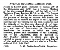
The 1967 liquidation meeting also wound up Middlewich Dairies and London and City Dairies - all of which had the same registered address at 15-17 Tavistock Sq. That was the former HQ of Express Dairies and is these days the Faculty of Public Health of the London School of Hygiene and Tropical Medicine.

There’s a pleasing circularity to all this, but my guess is that Avenue Hygienic Dairies was one of several long defunct arms of Express Dairies by 1967. The name is likely related to elsewhere, and Brixton was one branch among many, as Puddy_Tat says.

Still don’t know where that pic was taken though. ☹️
 
Must be pre-1914. Just looks like it. But also the hanging sign above the shop refers to the NTC (National Telephone Company), which was taken over by the Post Office in 1911.
Yes, but it's not uncommon for outdated signs to stay in situ years after a company has gone bust.
 
on flickr today


there were not that many places in london where there was room for a 'loading island' like this - usually passengers had to wait on the kerb then for other traffic between the tram and the kerb to stop for them
 
Some Brixton history from 15 years ago

Brixton Ten years Ago - Coldharbour Lane street works, Hovis sign and Herne Hill velodrome, March 2005


Brixton Ten years Ago - Coldharbour Lane street works, Hovis sign and Herne Hill velodrome, March 2005


Brixton Ten years Ago - Coldharbour Lane street works, Hovis sign and Herne Hill velodrome, March 2005


Brixton Ten years Ago - Coldharbour Lane street works, Hovis sign and Herne Hill velodrome, March 2005


It's been suggested that this is Brixton Skating Rink. Anyone know for sure?>

1585602875666.png
It looks the part: ;
 
It's been suggested that this is Brixton Skating Rink. Anyone know for sure?>

doesn't match picture in this article

can't place it. catford had a skating rink (picture here) but it's not that.

catford and brixton are the only two listed in 1919 post office london suburbs directory

ETA - little bit of research suggests I was aiming too late - sounds like there was a bit of a craze for roller skating in the late edwardian era, which largely passed when cinemas started to open. there's quite a few more skating rinks in the 1911 directory. can't get matches on any of them. and of course no certainty this one's actually london. have an annoying feeling i've seen the picture before, but can't place it.
 
Last edited:
Coldharbour Lane 1936

:)

although i'd put it closer to 1926 than 1936 - tram seems to be in 1920s London County Council livery, and service 76 ended in 1931 as part of a round of service changes when the Kingsway Subway re-opened (I did have to look that bit up) - and the 'weekly dispatch' stopped in 1928.

tram is in the process of changing over to overhead wire operation having run on conduit from central london - the 'change pit' and its attendant just visible on the left (changing from conduit to overhead did not require his assistance, the conduit 'plough' came out on its own, but the attendant had to help to get it under a tram heading the other way. possibly the conductor just visible behind the tram in the act of putting the trolley pole on the wire

Brixton Hill tram:

:)

and :eek: at electropathic belts
 
:)

although i'd put it closer to 1926 than 1936 - tram seems to be in 1920s London County Council livery, and service 76 ended in 1931 as part of a round of service changes when the Kingsway Subway re-opened (I did have to look that bit up) - and the 'weekly dispatch' stopped in 1928.

tram is in the process of changing over to overhead wire operation having run on conduit from central london - the 'change pit' and its attendant just visible on the left (changing from conduit to overhead did not require his assistance, the conduit 'plough' came out on its own, but the attendant had to help to get it under a tram heading the other way. possibly the conductor just visible behind the tram in the act of putting the trolley pole on the wire


:)

and :eek: at electropathic belts
Do you mind if I use your text for a Buzz feature? You're welcome to write something yourself, of course!
 
So here's a thing.

Call it cabin fever or home-working procrastination, or whatever, but yesterday I spent 3 hours lost in a black hole of geekery around the origins of Brockwell Park.

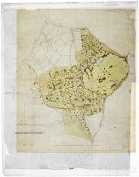
Having lived around its periphery for nigh on 20 years, I thought I knew all its secrets. But when a search on the RIBA photo library for an unrelated work project threw up this survey drawing of the Brockwell Estate from the turn of the C19th, it got me going.

Designs for the layout of the Brockwell and Tulse Hill estates, Lambeth, London: plan of the Tulse Hill and Brockwell estates | RIBA

Fascinating to see the Edwards property (now Tulse Hill) and the Blades property (now Brockwell Park) still as a single landscape of lanes and fields. Raleigh House on Brixton Hill is shown too, while the old Tudor Brockwell Hall still stands on Norwood Road. Blades' new Brockwell Hall on today's hilltop site is indicated in pencil, and Edwards' two new grand avenues of Tulse Hill and Upper Tulse Hill likewise. The natural dividing line between the two halves is not Tulse Hill the road (as I'd always thought), but the stream valley that forms the back gardens of the houses that fringe the western edge of the park. This valley includes of course Cressingham Gardens and the Brockwell Gate development.

Then I saw this one from 1823:

Designs for the layout of the Brockwell and Tulse Hill estates, Lambeth, London: plan showing proposed layout | RIBA

So there was a short period when Blades and Edwards jointly engaged JB Papworth (a big-name architect of his day) to explore a speculative development across both of their estates. By this time Blades' new Brockwell Hall had been standing for about ten years and Edwards had already started to lay out Tulse Hill as the southward continuation of Effra Road, but they considered at least something much bigger.

RIBA also have several pages of Papworth's drawings for Clarence House (the property demolished in the interwar expansion of the park, on the site now occupied by the BMX track), and for the two fine Grecian houses of 1828 called Brockwell Terrace that faced inwards to the park, and whose site is now under the Lido. The original St Jude's vicarage (not the post-war replacement that was done up on Grand Designs) was on the same alignment, so it's not too hard to imagine there was a grand scheme not unlike Nash's terraces overlooking Regent's Park, with big classical houses facing the greenery.

All this would have come to a halt when Blades died in 1829, so he had barely got started in the 20 years since the estate came under his ownership.

This got me thinking again. How much had he actually managed to change the landscape of fields and lanes that he started out with? And indeed how much was it changed again by JJ Sexby in the 1890s when Lambeth bought it for a park? And what survives today of all this?

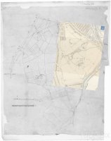
15 mins mucking about in Photoshop later - and wow. Not only did Blades simply plonk his mansion and kitchen garden in the middle of the biggest existing field, it looks like he left all the field boundaries in situ, grubbing up the hedgerows no doubt, but the trees continued to mark their positions when the first phase of the park was opened in 1892. Sexby's work was principally the addition of the peripheral path that goes either side of the old mansion gate at Herne Hill, and a sprinkling of amenities. It took another decade for the first Brixton gate to be opened on Arlingford Road, and 30 years more for the park to reach its present size as leases expired on the remaining houses and entrances were cut through to Tulse Hill and Brixton Water Lane. That story is pretty thoroughly told in lots of places, but it does explain why the BMX track and the scruffy area behind the Lido still feel somewhat 'other' and unfinished. And the Dulwich Road gate next to the Lido and the roadway that swings behind it and up to the BMX track is the old Clarence House carriage drive.

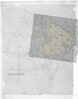
Finally I laid a screen cap from Google Maps over the whole lot. To this very day, all the principal paths in the park and the alignments of the trees reflect the field boundaries of more than 200 years ago. Now I can never see the place the same way again. This morning I walked up the path to the Hall from Herne Hill gate at about 7am and in the dawn light you can not only see the tree lines on the old field boundaries, but the humps where the hedges used to be too. Mind truly blown.

Here's a few of my overlays so everyone else can share the fun.
 

Attachments

  • brockwell1.jpg
    brockwell1.jpg
    614.7 KB · Views: 25
  • brockwell2.jpg
    brockwell2.jpg
    358.1 KB · Views: 25
  • brockwell3.jpg
    brockwell3.jpg
    429.7 KB · Views: 22
Nice colour pic

:)

also showing one of the few 'loading islands' where tram passengers could get on and off safely rather than in the middle of the road (compare and contrast with the next photo)

this was one of the official reasons for getting rid of trams in many places. the space for more loading islands was often not there, although the political will often wasn't either.

must be somewhere between mid 1947 (that sort of bus) and 1951 (last trams in Brixton)

Not sure if it's been posted before but it's a good 'un

somewhere between January and April 1951 (Brixton's tram services were replaced in two phases - bus 95 was a new tram replacement route in January, the Streatham / Purley route became the 109 in April.)

Latest on number 1's restoration at Crich Tramway Village from February -


1.1-kc-440x550.jpg


happyshopper

:)

knew it was still there. looking a bit tired.

and would look better if they chopped the telecoms tat off the roof.

and :) that they have kept the curved windows - look original. they can be a bit of a sod to replace, some of the houses near mum-tat's place (the area was developed in the mid / late 30s) had curved glass crittall windows, think the last one has now gone after the elderly occupant died and the house has been modernised...
 
More HOT TRAM ACTION!

probably also from 1951

the 'feltham' trams (as in the big red one in post 1523) and 'bluebird' (the one in 1524) got sold to Leeds and continued in service until about 1959, and started being taken away from Brixton before the end.

Both were intended to be the start of the third generation of London trams, built in the early 30s with comfier seats, better lighting, air brakes, a separate cab with seat for the driver, and interior heating (late 50's Routemasters were the first generation of London buses to have heating from new) - the Felthams were new in north / west London for the (Underground group owned) company tramways - about 100 were built, they got moved to Streatham Hill / Brixton Hill depots when those routes went trolleybus in 1937/8 - mainly because Streatham Hill depot needed less work than anywhere else to cope with bigger trams. The LCC were a couple of years behind, and No. 1 was a prototype.

London Transport had other ideas after 1933...
 
on tweeter today

DPnJnJFb


(collage page / larger image here - says it's 1907)

1904 / 1911 London Suburbs directories have this as 16 Hinton Road, just north of the junction of Milkwood Road.

Bit hard to place, as the street numbering had changed before the 1950 OS map

I think it's the building shown as 'ruin' on that map, which would make it about where Kingsley Point is now.

Advert in the window is for an event at the Surrey Masonic Hall, which was at 295 Camberwell New Road - more here
 
Last edited:
Back
Top Bottom