You are using an out of date browser. It may not display this or other websites correctly.
You should upgrade or use an alternative browser.
You should upgrade or use an alternative browser.
Extreme Weather Watch
- Thread starter ska invita
- Start date
bcuster
Well-Known Member
Helene is posing a SERIOUS threat:

 www.usatoday.com
The forecast for Helene to transition from a potential tropical cyclone to a Category 3 hurricane appears to be the fastest progression ever predicted for a depression by the National Hurricane Center.
perhaps the US Midwest will get some badly needed rain...

Helene now projected as Category 4 hurricane, could get stronger: Updates
The highest landfall probability is somewhere along the eastern part of the Florida Panhandle late Thursday evening, forecasters said.
The forecast for Helene to transition from a potential tropical cyclone to a Category 3 hurricane appears to be the fastest progression ever predicted for a depression by the National Hurricane Center.
perhaps the US Midwest will get some badly needed rain...
Last edited:
brogdale
Coming to terms with late onset Anarchism
The predicted rainfall totals from Helene look frightening and very extensive:
RAINFALL: Hurricane Helene is expected to produce total rain accumulations of 4 to 8 inches over western Cuba, the Cayman Islands and the northeast Yucatan Peninsula, with isolated totals around 12 inches. This rainfall brings a risk of considerable flooding.
Over portions of the Southeastern U.S. into the Southern Appalachians, Helene is expected to produce total rain accumulations of 6 to 12 inches with isolated totals around 18 inches. This rainfall will likely result in catastrophic and potentially life-threatening flash and urban flooding, along with significant river flooding. Numerous landslides are expected in steep terrain across the southern Appalachians.
Rainfall totals of 2 to 6 inches are expected across portions of the Tennessee Valley, Ohio Valley and lower to mid Mississippi Valley.
bcuster
Well-Known Member
Lord Camomile
Yipchaa!
.
brogdale
Coming to terms with late onset Anarchism
Just heard warnings for residents with EVs to move them out of the storm surge's harm as they pose a fire risk when submerged with salt water. Apparently some homes that withstood the winds/surge of the 2022 Hurricane Ian actually burnt down because of EV fires. 

WouldBe
Dislicksick
If the houses survived the storm surge how did the EV's get submerged.Just heard warnings for residents with EVs to move them out of the storm surge's harm as they pose a fire risk when submerged with salt water. Apparently some homes that withstood the winds/surge of the 2022 Hurricane Ian actually burnt down because of EV fires.

brogdale
Coming to terms with late onset Anarchism
Structurally survived, I assume.If the houses survived the storm surge how did the EV's get submerged.
bcuster
Well-Known Member

【LIVE】 Webcam Perdido Key | SkylineWebcams
Watch our Perdido Key Beach live cam in Florida. Check out the stunning white sands and crystal-clear waters right from your device.
 www.skylinewebcams.com
teqniq
DisMembered
Thread of flood vids from the month of September:

 threadreaderapp.com

Thread by @volcaholic1 on Thread Reader App
@volcaholic1: 🧵 I've put together this thread to show just how much flooding has happened around the world, and this is only for the month of September—and it's not even over yet! Please share this because...…
ska invita
back on the other side

Nepal floods: Almost 150 dead and dozens missing after days of heavy rainfall around Kathmandu
People are left stranded on rooftops in Kathmandu with workers carrying out rescues on rafts.
www.bbc.co.uk
Pickman's model
Starry Wisdom
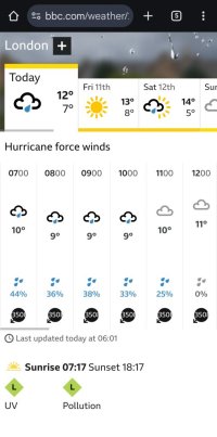
Ha, tis but a breeze.Fuck me it'll be windy in London today - never heard of such strong winds
View attachment 446222
Attachments
Last edited:
Pickman's model
Starry Wisdom
I'm blown awayHa, tis but a a breeze.
frogwoman
No amount of cajolery...
I guess the frequency and duration of Category 5 hurricanes is increasing and that's what's down to climate change rather than the fact such storms occur at all.It is certainly quite late in the season for cat 5s in the Gulf Of Mexico. There have only been two before in October (in recorded history).
frogwoman
No amount of cajolery...
What about winter storms like Storm Dennis etc which seem to be formed via different mechanisms?There does seem to be a gradual upward trend. The systems are complex, but almost certainly sea surface temperatures (and associated dynamics), modulated by climate warming, are a significant driver.
bcuster
Well-Known Member
Aren't these storms called Northeasters? Is that something else entirely?What about winter storms like Storm Dennis etc which seem to be formed via different mechanisms?
Similar threads
- Replies
- 21
- Views
- 1K
- Replies
- 17
- Views
- 1K
- Replies
- 7
- Views
- 491


