
You are using an out of date browser. It may not display this or other websites correctly.
You should upgrade or use an alternative browser.
You should upgrade or use an alternative browser.
My 'mental map' of Brixton is upside down.
- Thread starter Crispy
- Start date
gaijingirl
Well-Known Member
Yeah.. I tend to do that.. I think it's 'cos of the hills at the South end - mentally things start up there and then taper off down into the town centre. That and the old postcode argument I guess!
Donna Ferentes
jubliado
I spent ages under the impression that the High Street ran west to east when it basically runs south to north.
Minnie_the_Minx
someinenhhanding menbag and me ah bollox
I'm not getting involved in this conversation as I'm already confused.
But, as Brixton Hill goes UP, I consider it North
But, as Brixton Hill goes UP, I consider it North
poster342002
PROPER leftwing socialist
Surely Tesco is nearer to Brixton's most westerly point?Enid Laundromat said:I think of Tescos as the most northerly point, with the barrier block as the south pole, Brixton Hill to the west and Brixton Road going west.
I'd also say that:
Loughborough Junction is it's most easterly (although some would say it's not quite part of Brixton as such).
The junction between Brixton Road and Loughborough Road is it's most northerly point.
Brixton Hill it's southernmost point.
Perhaps more controversially, I tend to think of Victoria as being South London's northernmost point (yes, I know it's actually over the river)!
scotlander
New Member
tesco is clapham easts most westerly point
gaijingirl
Well-Known Member
poster342002 said:Surely Tesco is nearer to Brixton's most westerly point?
!
I think she's talking about the mini Tescos garage on Brixton Road out on the way to Jamm.
gaijingirl
Well-Known Member
do you mean easterly point?scotlander said:tesco is clapham easts most westerly point
scotlander
New Member
easterly, yes....
Minnie_the_Minx
someinenhhanding menbag and me ah bollox
poster342002 said:Perhaps more controversially, I tend to think of Victoria as being South London's northernmost point (yes, I know it's actually over the river)!
What about Chelsea or Earls Court?
gaijingirl
Well-Known Member
For me it goes from the top of Brixton Hill and where Tulse Hill meets Upper Tulse Hill (despite that point being slightly more southern than the top of Brixton Hill) to Loughborough Junction in the east and the 100 pub in the West and around about where Jamm is in the North. But this has very much to do with where I go and where I've lived in Brixton.
i think i imagine it the 'right way up' - ie the police station at the top, Mass at the bottom etc - but that's probably because I've almost always lived south of Brixton
poster342002
PROPER leftwing socialist
Strangely, I tend to think them as perhaps being West London's most southerly point.Minnie_the_Minx said:What about Chelsea or Earls Court?
Shippou-Sensei
4:1:2.5
my mental map of brixton
is non pictorial really
perhaps a sort of wireframe interface if i really think about it ... freely movable
is non pictorial really
perhaps a sort of wireframe interface if i really think about it ... freely movable
gaijingirl
Well-Known Member
scotlander said:easterly, yes....
When I was living on Plato Road (off Acre Lane which is more or less opposite the Horse and Coaches) and AFAIC and the PO is most definitely Brixton and not Clapham, I met someone who, response to me saying that I lived in Brixton, slagged off Brixton and said Clapham was much nicer. Turned out she lived on Corrance Road.. a couple of roads further east and towards Brixton town centre...

poster342002
PROPER leftwing socialist
Then there's the Herne Hill/Brockwell Park area. Not quite Brixton in my mind, but a contender for it's sourthern border.
Minnie_the_Minx
someinenhhanding menbag and me ah bollox
poster342002 said:Then there's the Herne Hill/Brockwell Park area. Not quite Brixton in my mind, but a contender for it's sourthern border.
Not the Eastern border?
oh, god, i just KNEW it would descend into squabbling about where brixton actually starts and ends. I thought this was about what way UP it was
Crispy
The following psytrance is baṉned: All
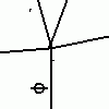
This is how I start drawing a map of brixton if I have to give someone directions. It must be confusing if you're used to reading maps with North pointing up ")
PS: If anyone wants to get a team of covert street painters together and actually mark the border of brixton down, I'd be happy to help end this silly argument once and for all.
PS: If anyone wants to get a team of covert street painters together and actually mark the border of brixton down, I'd be happy to help end this silly argument once and for all.
Attachments
poster342002
PROPER leftwing socialist
No, I'd say that'd more be the Loughborough Junction area. Herne Hill could be it's South-Eastern border, though.Minnie_the_Minx said:Not the Eastern border?
Minnie_the_Minx
someinenhhanding menbag and me ah bollox
Crispy said:This is how I start drawing a map of brixton if I have to give someone directions. It must be confusing if you're used to reading maps with North pointing up
PS: If anyone wants to get a team of covert street painters together and actually mark the border of brixton down, I'd be happy to help end this silly argument once and for all.
The tube's on the wrong side of the road
superdoopa
New Member
brixton hill definitely south... you've always got the view of the city to realign yourself...
Minnie_the_Minx
someinenhhanding menbag and me ah bollox
poster342002 said:No, I'd say that'd more be the Loughborough Junction area. Herne Hill could be it's South-Eastern border, though.
poster342002
PROPER leftwing socialist
Where would we say that bit of Brixton Road that runs between just beyond the junction with Loughborough Road and Oval is? Is that area part of Brixton or Kennington or what? 
that's brixton till the end of brixton road, then it's oval for a few metres, then it's kennington
Minnie_the_Minx
someinenhhanding menbag and me ah bollox
Does anyone ever actually claim to live in Oval?
Crispy
The following psytrance is baṉned: All
No it's notMinnie_the_Minx said:The tube's on the wrong side of the road
Similar threads
- Replies
- 49
- Views
- 3K
- Replies
- 6
- Views
- 406